On average, rural residents live farther away from hospitals compared to urban residents. Cassie Lewis Odahowski, an assistant professor of public health at the University of South Carolina, says those longer distances can lead to worse health outcomes.
Odahowski saw this reality play out firsthand when her grandfather was diagnosed with lung cancer. As a rural resident, he relied on his family to drive him an hour each way to get to appointments. His cancer was caught too late to treat beyond palliative care.
“This all happened in 2013, and it got me thinking: What do people do when they live in rural areas and they don't have a car or other resources available?” she says. “I started digging into rural health research, and the data was shocking to me — the health outcomes and differences between urban and rural.”
This realization led Odahowski, who grew up in a rural town in Florida, to USC’s Arnold School of Public Health, where she earned her doctorate in epidemiology. Now a USC faculty member and researcher for the school’s Rural Health Research Center, Odahowski studies access-to-care issues for rural communities in South Carolina and nationwide.
“Too often our rural population struggles to overcome barriers to access consistent care, and it plays out in the way that it did for my grandfather, where you just don't catch things as soon as you could. That impacts people’s experience and survival,” she says.
Odahowski specializes in spatial epidemiology — how geography impacts disease and health outcomes. In analyzing data, she uses ArcGIS, an advanced online mapping tool that allows researchers to dig deeper into data for findings that may not be readily apparent. The software provides access to useful data that is not available online — like road networks — and makes it easier for researchers to use it.
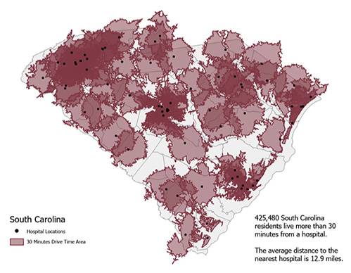
Odahowski and team created this map using ArcGIS Pro to show the actual travel time it takes South Carolina residents to get to the nearest hospital and to capture the total number of people without adequate access.
Consider travel distance: Looking at one set of data, researchers could say that South Carolina residents need to travel an average distance of 12.9 miles to reach a hospital. That’s true, but Odahowski says this average doesn’t factor in the population density of the metropolitan areas. In rural areas, people are much more spread out. Traditional mapping techniques may capture distance with a simple circle or straight line, overlooking the time it takes to drive winding back roads.
“One frustrating thing I come across is when people just use circular catchment areas to measure distance to health care, because that doesn't reflect real life travel patterns,” Odahowski says. “The map created with ArcGIS shows us the areas across our state that are beyond a 30-minute travel time based on our road network. In actuality, South Carolina has more than 425,000 residents who live more than 30 minutes from a hospital.”
Odahowski says the tool has been incredibly valuable to her research at USC because it makes complicated analyses with multiple variables easier to visualize and understand. This combination of precision and flexibility helps when researchers are trying to figure out the whole story behind their findings. At first glance, a correlation might seem obvious, but Odahowski says using the software sometimes yields unexpected results.
In a recent project for the Rural Health Research Center, Odahowski has used ArcGIS to look at national Medicaid data on preventative dental care for children. They identified lower rates of adequate dental cleanings for Medicaid-insured children across the board, but ArcGIS allowed them to look at this change through the lens of multiple variables, including rural vs. urban communities and underlying socioeconomic factors.
“In our analyses, we often see poverty and insurance type are drivers behind the observed rural disparities,” she says. “These factors greatly impact peoples’ ability to access health care.”
Odahowski’s team is going to further refine their maps, updating them to show the kids who were on Medicaid and who lived in a rural area — with an overlay of the dental care data. By better understanding the multiple factors contributing to inadequate care, researchers will be able to map out more helpful possibilities to combat the issues these children face.
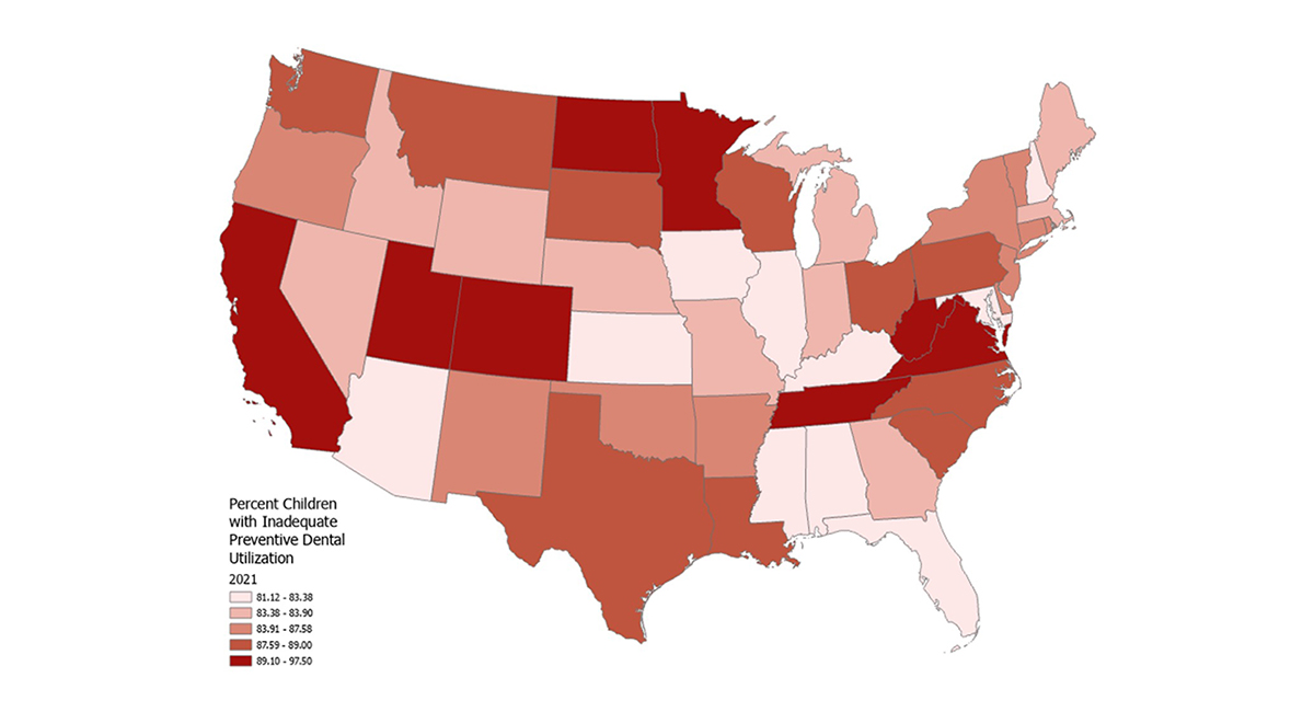
National Medicaid claims data show the percentage of inadequate dental care for children (less than two cleanings) in 2021. Odahowski and team are working to identify the factors that contribute to inadequate care – from lack of providers in rural areas to poverty in general or complex factors like lingering pandemic-era restrictions.
A national research asset at USC
ArcGIS was brought to USC in large part thanks to Kevin Haynes, who serves as GIS director for the Department of Geography and was last year named the university’s first Geospatial Information Officer. Haynes is working to help university faculty and students in all departments learn about ArcGIS, which is available through University Libraries.
“Kevin has been a godsend in opening the door for me to find all of these other resources within the GIS system that I wasn't previously connected with — training on how to use the software and data sources that are available,” Odahowski says.
Odahowski is teaching her graduate students how powerful the new software can be for data analysis, and she has also used the tool to bolster her research at the national level.
In 2025, Odahowski served a one-year term as a fellow with the National Rural Health Association and worked with a team to examine a policy issue impacting rural health. They collected data, wrote a policy brief and presented their findings to inform the association’s advocacy priorities for the coming year.
“We looked at regulations that were passed in the 1990s that impact how the federal Centers for Medicare & Medicaid Services reimburses critical access hospitals, which are disproportionately located in rural areas,” Odahowski says.
Their brief identifies how these regulations impact hospital operations and patient care. The association will now present their recommendations to policymakers in Washington, D.C., supporting a bill to roll back the outdated regulations. As a member of a small team of researchers based in the southeast region, Odahowski was the only fellow with access to ArcGIS.
“Maps are impactful for messaging because a map communicates so much better than just reading out numbers. I think people identify really well with maps, because people see a map and they want to talk about where they live and how the data you’re showing reflects what they experience. Especially when we connect with our policymakers, ArcGIS shows how issues impact the people they represent,” she says.